Fayl:Map of USA AK full.png
Daha yüksək versiyası yoxdur.
Map_of_USA_AK_full.png (284 × 184 piksel, fayl həcmi: 19 KB, MIME növü: image/png)

|
File:Map of USA AK full.svg is a vector version of this file. It should be used in place of this PNG file when not inferior.
File:Map of USA AK full.png → File:Map of USA AK full.svg
For more information, see Help:SVG. |
 |
Xülasə
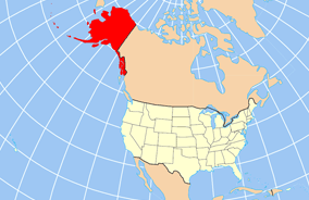
| İzah | Map of USA with Alaska highlighted and shown in true position |
| Tarix | |
| Mənbə | http://www.nationalatlas.gov/printable/reference.html |
| Müəllif | |
| Digər versiyalar | File:Map of USA AK full.svg |
Lisenziya
This map was obtained from an edition of the National Atlas of the United States. Like almost all works of the U.S. federal government, works from the National Atlas are in the public domain in the United States.
Online access: NationalAtlas.gov | 1970 print edition: Library of Congress, Perry-Castañeda Library
|
Faylın tarixçəsi
Faylın əvvəlki versiyasını görmək üçün gün/tarix bölməsindəki tarixlərə klikləyin.
| Tarix/Vaxt | Kiçik şəkil | Ölçülər | İstifadəçi | Şərh | |
|---|---|---|---|---|---|
| indiki | 20:43, 17 dekabr 2012 | | 284 × 184 (19 KB) | Ras67 | cropped |
| 16:31, 2 aprel 2007 |  | 286 × 186 (20 KB) | MattWright | fix to more standard map colors | |
| 06:20, 2 aprel 2007 |  | 286 × 186 (19 KB) | MattWright | {{Information |Description=Map of USA with Alaska highlighted and shown in true position |Source=http://www.nationalatlas.gov/printable/reference.html |Date=2007-04-02 |Author= |Permission= |other_versions= }} Category:Maps of the United States [[Cat |
Fayl keçidləri
Aşağıdakı 7 səhifə bu faylı istifadə edir:
Faylın qlobal istifadəsi
Bu fayl aşağıdakı vikilərdə istifadə olunur:
- am.wikipedia.org layihəsində istifadəsi
- ar.wikipedia.org layihəsində istifadəsi
- az.wikipedia.org layihəsində istifadəsi
- ba.wikipedia.org layihəsində istifadəsi
- bn.wikipedia.org layihəsində istifadəsi
- ce.wikipedia.org layihəsində istifadəsi
- cy.wikipedia.org layihəsində istifadəsi
- da.wikipedia.org layihəsində istifadəsi
- de.wikipedia.org layihəsində istifadəsi
- el.wikipedia.org layihəsində istifadəsi
- en.wikipedia.org layihəsində istifadəsi
- es.wikibooks.org layihəsində istifadəsi
- fa.wikipedia.org layihəsində istifadəsi
- fr.wikinews.org layihəsində istifadəsi
- ga.wikipedia.org layihəsində istifadəsi
- Sitka
- Buirg Aleutians Thoir, Alasca
- Buirg Anchorage, Alasca
- Buirg Artach Thiar Thuaidh, Alasca
- Buirg Bristol Bay, Alasca
- Buirg Denali, Alasca
- Buirg Fairbanks Réalta Thuaidh, Alasca
- Buirg Haines, Alasca
- Buirg Juneau, Alasca
- Buirg Leithinis Kenai, Alasca
- Buirg Tairseach Ketchikan, Alasca
- Buirg Oileán Kodiak, Alasca
- Buirg Loch agus Leithinis, Alasca
- Buirg Matanuska-Susitna, Alasca
- Buirg Fána Taobh Thuaidh, Alasca
- Buirg Petersburg, Alasca
- Buirg Sitka, Alasca
- Buirg Skagway, Alasca
- Buirg Wrangell, Alasca
- Buirg Yakutat, Alasca
- Buirg Neamheagraithe, Alasca
Bu faylın qlobal istifadəsinə baxın.